Project Description
Nordic Seas
SUMMARY
The Nordic Seas regional facility comprises 5 ocean glider sections, 4 mooring sites, and one multi array observatory. The facility is a mixture of existing monitoring components, which are expanded, and new establishments and the main aim is to contribute to increased understanding of the role of the Nordic Seas in the global climate system. Particularly, the multidisciplinary research conducted at Nordic Seas regional facility focuses on:
- Water transport, circulation and water mass properties of the Nordic Seas
- Sub-surface biogeochemistry • Methane release from seafloor
- Front variability between Polar and Atlantic Water
- Geophysical, oceanographic and ecological characterization of a hydrothermal vent
The activity at the Nordic Seas regional facility is shown in the map, where the ocean glider transects are indicated with red lines and numbers, the mooring sites are indicated with white circles and named Svinøy, Station M, South Cape, and Fram Strait, and the multi array observatory is indicated with a white circle and named EMSO-Mohn.
EMSO scientific disciplines: physical oceanography, biogeochemistry, marine ecology (planned)

Credit: Ilker Fer, UiB
General information
Location: Norwegian Sea, Greenland Sea, Iceland Sea, Fram Strait
Distance from land:see site information below
Max water depth: see site information below
Date 1st deployment: see site information below
Supported by: Research Council of Norway, Norway
Operated by: see site information below
Website: https://www.uib.no/en/noremso/
Status: see site information below)
Regional Team Leader: Ilker Fer, University of Bergen (UiB), see below for site PIs
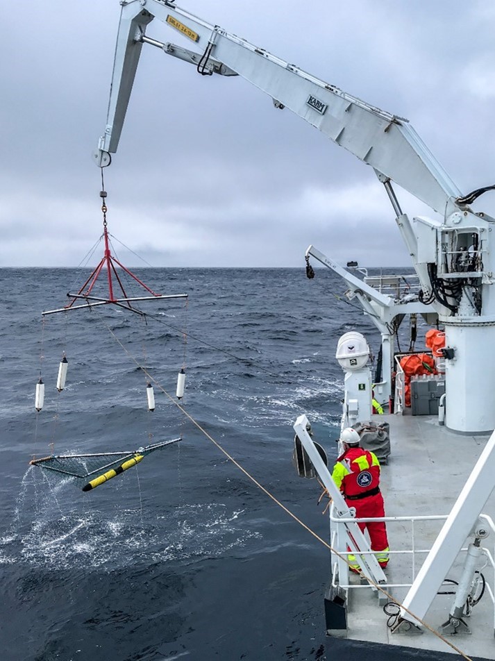
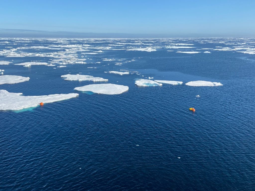
Credit: Photo 1: Jane Møgster, IMR, Photo 2: Laura de Steur, NPI, Photo 3: Thibaut Barreyre, UiB
Scientific objectives
The overarching scientific objective of Nordic Seas is to better understand the drivers for the temporal and spatial changes of water mass transformations, ocean circulation, acidification, and thermo-chemical exchanges at the seafloor in the Nordic Seas, and to contribute to improvement of models and forecasting by producing and making available high quality near real time data.
Description of the infrastructure
The Nordic Seas regional facility includes ocean gliders, moorings, and a multi array observatory. The different components are described below.
Glider infrastructure
Location: Norwegian Sea (Svinøy: 62.7°N, 4.4°E – 64.7°N, 0.0°E; Gimsøy: 68.8°N, 13.0°E – 70.2°N, 8.8°E), Fram Strait (78.8°N, 9.0°E – 78.8°N, 7.0°W), Greenland Sea (73.5°N, 2.0°E – 76.4°N, 7.8°W), Iceland Sea (70.6°N, 10.0°W – 71.0°N, 19.6°W)
Distance from land: variable
Max water depth: variable
Date 1st deployment: 2020 within the EMSO framework
Operated by: University of Bergen (UiB), Norwegian Polar Institute (NPI), and Institute of Marine Research (IMR)
Website: https://www.uib.no/en/noremso/140162/infrastructure#glider-observationsystems
Status: full deployment started summer 2021
PI: Ilker Fer, UiB
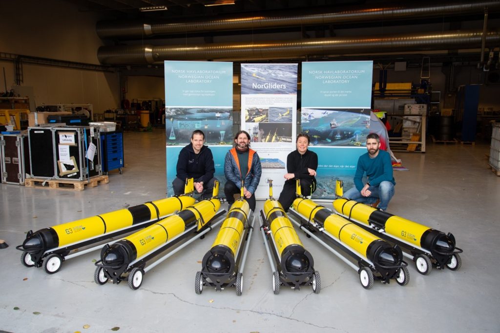
Credit: Algot Peterson, UiB
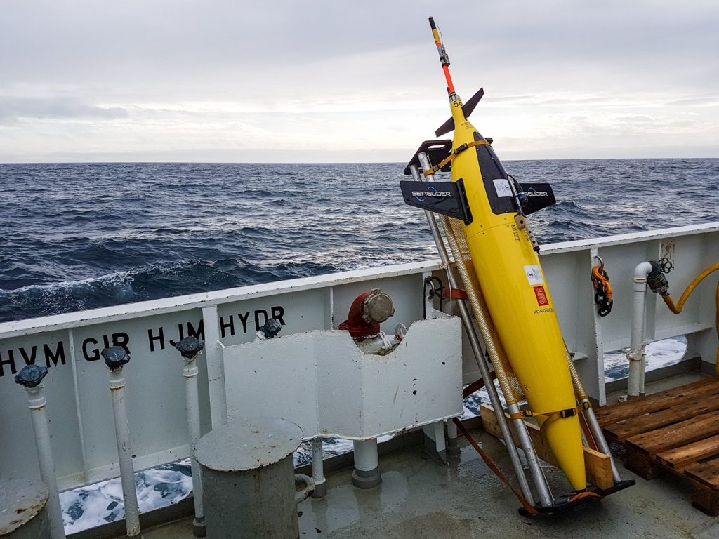
Gliders are operated to monitor circulation and water mass properties at key locations in the Nordic Seas (see map above). All gliders measure temperature, salinity, and pressure, while depth-averaged velocity is derived from the difference between the glider’s velocity over ground and its velocity through water.
New Slocum gliders were acquired in fall 2020 and trial deployments were commenced later that year. Following firmware upgrades, all transects will be in full operation from summer 2021 onward. The rechargeable gliders will be serviced during monitoring cruises in the Norwegian Sea. The endurance gliders will be serviced during annual cruises to the EMSO Mohn multi array site. Decimated profiles are transmitted from the gliders at every surfacing. The full set of measurements will be downloaded from the gliders when they are serviced and made available after quality control and calibration.
Mooring infrastructures
Svinøy mooring site
Location: From 63°N 4°E and toward northwest in the southern Norwegian Sea
Distance from land: 100 km west of Norway
Max water depth: 500 to 3000 m
Date 1st deployment: 1995-2020 (UIB), 2020 (IMR). May 2020 within the EMSO framework
Operated by: Institute of Marine Research (IMR)
Website: https://www.uib.no/en/noremso/140162/infrastructure#moored-observationsystems
Status: running
PI: Øystein Skagseth, IMR
The Svinøy section is located in a confluence region cutting through the two-branched Norwegian Atlantic Current (NAC). The main objective of the Svinøy mooring site is to perform transport estimates based on current measurements of the western branch of NAC, which has a history back to 1995, and to extend the transport estimated to also include the western branch. The transport series in the Svinøy section is also an integrated part of the repeated hydrographic and plankton surveys performed by IMR since 1977, and a glider missions in the southern Norwegian Sea.
The main mooring at the Svinøy mooring site is located over the 500 m isobath at 63N, 4E is used to estimate transport variability in the western branch of the NAC at time scales exceeding one month. Additional, four current meter (Aanderaa Seaguard) moorings are distributed over the 1000, 1500, 2000 and 2500 m isobaths.
Credit: Ø. Skagseth, IMR
Station M mooring site
Location: at 66°N 2°E in the Norwegian Sea
Distance from land: 236 NM – 430 km from the Norwegian coast
Max water depth: 2050 m
Date 1st deployment:1948 (first measurement); 1994 (first mooring); 2020 (first EMSO mooring)
Operated by: University of Bergen (UiB) and NORCE Norwegian Research Centre (NORCE)
Website: https://www.uib.no/en/noremso/140162/infrastructure#moored-observationsystems
Status: running
PI: Ingunn Skjelvan, NORCE
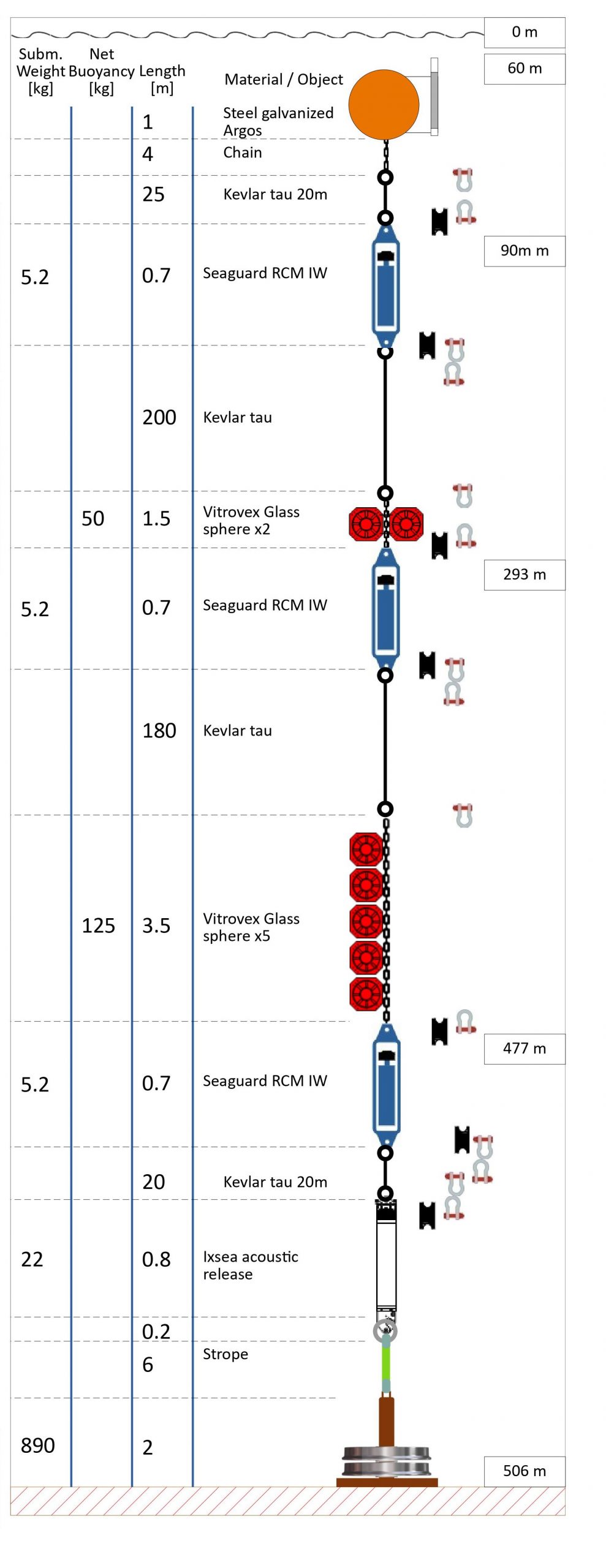
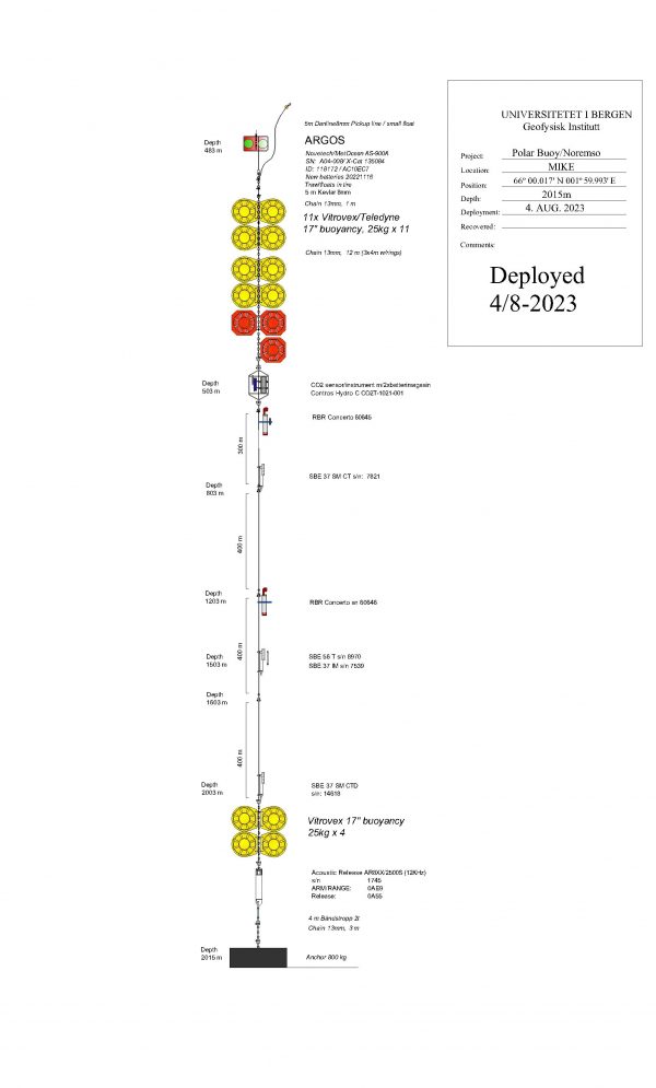
Station M is situated at the western branch of the Norwegian Atlantic Current and it was started in 1948 as an ocean weather ship station. Moorings were first used in 1994 and currently, a single array deep mooring is deployed at the site. The mooring provides short- and long-term variability of the inorganic carbon cycle and hydrography and from this, information about the state of acidification, its variability, and furthermore, the drivers of the observed changes are extracted. The long time-series from the station contribute to a better understanding of the climate system and its variability.
The observatory consists of a single mooring situated between 500 and 2000 m depth, with sensors for temperature, salinity, pressure, and pCO2 measurements. Dissolved oxygen measurements will be included. The mooring is usually deployed for a year at the time. The data are downloaded after the mooring is retrieved.

Credit: Warming of the deep water at Station M (credit: S. Østerhus, NORCE)
Credit: T. de Lange, UiB
South Cape mooring site
Location: at 76.107°N 15.967°E, off South Cape of Svalbard, gas hydrate Pingo
Distance from land: 28 NM – 52 km from western coast of Svalbard
Max water depth: 390 m
Date 1st deployment: Planned in December 2021
Operated by: UiT – The Arctic University of Norway (UiT)
Website: https://www.uib.no/en/noremso
Status:in development
PI: Bénédicte Ferré, UiT

Credit: Bathymetry of the gas hydrate pingo area. The white lines represent bubble streams.
More than thousands of seepages of methane, potent greenhouse gas that could enhance climate warming if it reaches the atmosphere, cover the Norwegian and Svalbard continental margins. In particular, a gas hydrate pingo located south of Svalbard is persistently emitting natural gas. Methane bubbles are rising as high as 20 m below the sea level at this location. The South Cape mooring site will consist of a seabed and water column observatory aiming at monitoring the methane seepage activity and transport in the water column. In addition, it will monitor oceanographic processes from the seafloor to the sea surface.
The infrastructure will use an existing seafloor observatory (K-lander) along with a watercolumn mooring. Both components will be equipped with physical and chemical sensors (hydrophone, ADCP, CTD, pH, CH4 and CO2 sensors). The deployment is scheduled in December 2021 to be confirmed. In addition, the location will be crossed by a glider section.

Credit: Bénédicte Ferré, UiT
Central Farm Strait mooring site
Location: 78.83°N 2°W in the Fram Strait
Distance from land: 280 km west of Svalbard
Max water depth: 2655 m
Date 1st deployment:1997-2016 (AWI), 2017-2020 (NPI), August 2020 (first EMSO mooring)
Operated by: Norwegian Polar Institute (NPI)
Website: https://www.uib.no/en/noremso/140162/infrastructure#moored-observationsystems
Status: running
PI: Laura de Steur, NPI

mooring array in the Fram Strait
Sketch of the mooring array in the Fram Strait with the EMSO Central Fram Strait mooring F10 complementing the Fram Strait Arctic Outflow Observatory (NPI).
The Fram Strait mooring (F10) captures the recirculating Atlantic Water in the Fram Strait which merges with the East Greenland Current (EGC) to flow southward. The upper ocean here is marked by the Polar-Atlantic Waterfront and shows alternating fresh and cold Polar Water coming from the EGC and warm and saline Atlantic Water arriving from the West Spitsbergen Current (WSC). The flow is west-south-westward and is significantly stronger in winter, driven by stronger wind forcing over the Greenland Gyre in winter. The returning Atlantic Water gets denser as it gets cooled and is a source water for the Denmark Strait Overflow further south.
The mooring F10 was installed and maintained by the Alfred Wegener Institute (AWI) in 1997- 2002 at 79°N and between 2002-2016 at 78.83°N. From 2017-2020 it was maintained at 78.83°N by NPI. As of 2020 it will be continued by the NPI within EMSO. Chemical measurements, DO and pH/pCO2, are included at the station as of 2020 and 2021 respectively. Additional measurements are salinity, pressure, and current meters. The mooring will be serviced each year in August-September during the annual cruise of the Norwegian Polar Institute to the Fram Strait to service the Fram Strait Arctic Outflow Observatory.

Credit: Yannick Kern, NPI
Multi array observatory EMSO-Mohn
Location: 72.756°N 3.834°E at the Mohn’s Ridge (Fåvne vent field)
Distance from land: 325 NM – 600 km from western coast of Norway
Max water depth: 3050 m
Date 1st deployment: Summer 2022
Operated by: University of Bergen (UiB)
Website: https://www.uib.no/en/noremso/140162/infrastructure#emso-mohn
Status:in development
PI: Thibaut Barreyre, UiB

Credit: Thibaut Barreyre, UiB
EMSO Mohn is an observatory which will be establish at a the newly discovered hydrothermal vent field Fåvne at the Mohn Ridge. The observatory will be a fixed-point seabed-water-column-coupled and wireless observatory with a multidisciplinary approach – from geophysics and physical oceanography to ecology and microbiology. Fåvne vent field is an ultramafic-hosted hydrothermal system located on the ultra-slow spreading Mohn’s ridge where the oceanographic front between the cold waters in the Greenland Sea and the warm waters in the Norwegian Sea meet. It is primarily directed at understanding the dynamics and magnitude of the coupling between the hydrothermal plume, rough bathymetry and oceanographic processes and its impact on the biosphere and surrounding water masses in the Nordic Seas.
The observatory is currently in development and is scheduled for deployment in summer 2022. It will be composed of one deep-ocean water-column mooring coupled with a seafloor node, and of a transmission buoy that communicates acoustically with the seafloor station and relays data (hydrothermal, background seawater and oceanographic properties – e.g., pressure, temperature, turbidity, current-, and system status) via satellite to the EMSO data center hosted at the University of Bergen, Norway. The observatory will be complemented with autonomous seafloor instruments.

Credit: Thibaut Barreyre, UiB (distributed via imaggeo.egu.eu)