
ACCESS TO THE INFRASTRUCTURE 2026 CALL
Welcome to the fifth EMSO ERIC call for physical access to the Regional Facilities, an initiative started in 2022. This year seven regional facilities offer access to external users, providing access to five open ocean sites and two shallow test sites.
The objective of this call is to offer physical access to EMSO Facilities where users’ devices can be installed, including sensors, instruments, systems, new technologies and where new procedures/experiments can be tested/take place. The set of Regional Facilities offered for access provides the broadest scientific and technological capabilities to future users. In 2026, seven Facilities are available, three at the Atlantic Ocean and four at the Mediterranean Sea.
This is a unique opportunity for scientists and research engineers to avail of high-quality, interlinked instrumented platforms operating in open ocean for carrying out research and/or testing activities. Regional Facilities’ engineers and scientists can also provide training and co-development to users interested in learning specialised techniques/methodologies and developing new products, taking advantage of years of experience gathered at EMSO Facilities’ labs. Tailored data collection by the Facilities’ instruments is another service that may be provided.
The evaluation of project proposals will be performed every two months and the selected ones will be funded.
Funding consists in Facility Access Units (days of usage) and economic support for operations, travel, shipping and consumables. This economic support amounts to 90.000 euros for all projects in 2026 and will be distributed evenly among the six cut-off dates. This 2026 call is expected to fund a minimum of six projects.
All material for responding to the call and requesting access will be made available through this website section: Application Steps, Application Rules, Available Facilities, Letter of Intent, Project Proposal Form.
IMPORTANT DATES
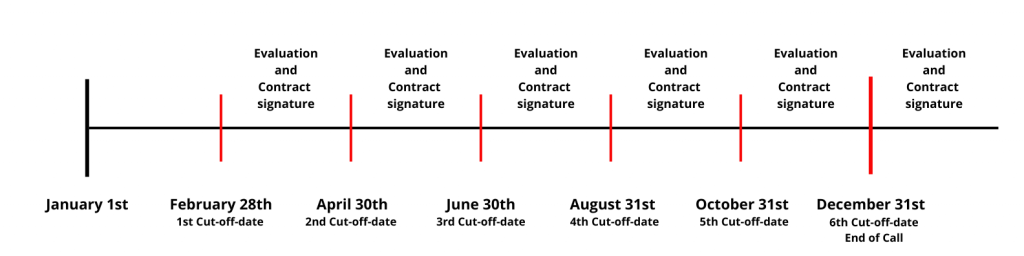
The 2026 call is currently open and applications can be submitted until December 31st, 2026. There are six cut-off dates in which proposals received before their deadlines will be evaluated and, if positive, given green light for execution on the programmed dates. Please check the selected regional facility special requirements, provided services, availability, costs and operational constraints.
HOW TO PROCEED
- Send to EMSO ERIC this Letter of Intent
- The chosen Facility manager will get back to you to prepare a Project Proposal
- Send the proposal to EMSO ERIC and wait for evaluation
- Sign contract and execute project
Signed application forms should be sent in PDF to physical-access[AT]emso-eu[DOT]org

APPLICATION STEPS
Call opening
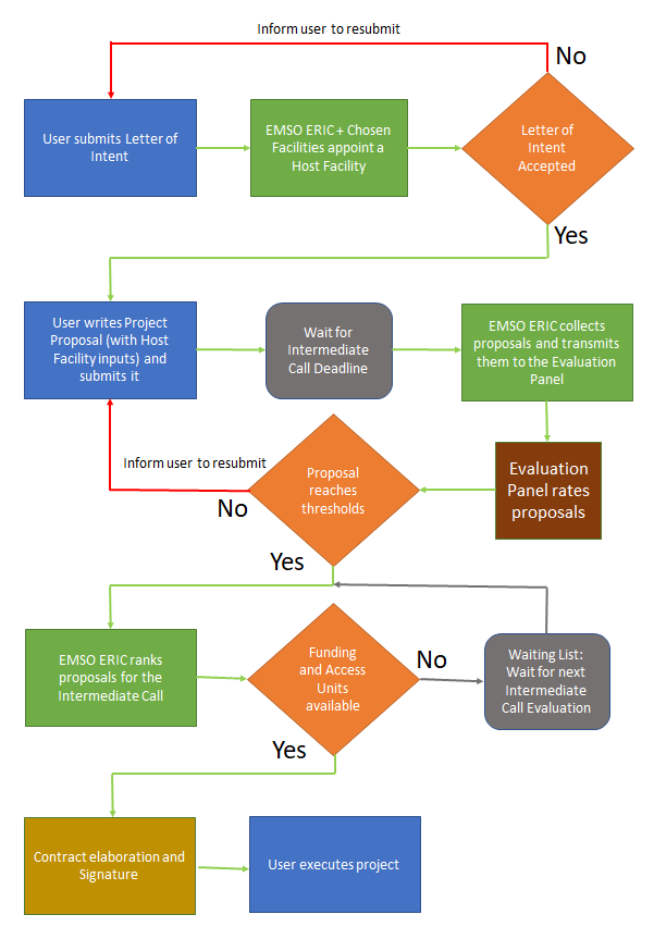
The call is open from January 29th to December 31st 2026, proposals can be sent anytime and will be evaluated in six cut-off dates: February 28th , April 30th, June 30th , August 31st, October 31st and December 31st . The period of access needs to be discussed with the chosen regional facility(ies). Depending on the nature of the experiment it can be days, weeks or months and can be performed in 2026, 2027 and 2028. The project starting date and kick-off meeting must be within 8 months of the cut-off deadline it is submitted to. For a clear view of the process, from Letter of Intent to Project Execution, please consult the chart at the bottom of this page. The physical access contact point is available for questions regarding the call. You can send an email to physical-access@emso-eu.org.
Letter of intent
The interested applicant needs to fill out a letter of intent and send it to the EMSO physical access dedicated email. In this letter, the applicant formalises the interest to participate in the EMSO physical access programme and provides a one page project proposal. EMSO will treat the information in a totally confidential manner and will by no means distribute or publicise the applicant’s ideas and proposals.
Host facility assignment
The managers of the regional facilities selected by the applicant will be contacted by the order of preference provided by the applicant and shown the one page project proposal. The available facility(ies) manager(s) will contact the applicant to prepare the project proposal. If the one page proposal is seen as unfeasible by the facility managers, the applicant will be contacted and asked to reformulate the proposal.
Joint project proposal
The applicant will fill in the project proposal form once one or more host facilities have been appointed. This will be a more detailed document in which the applicant will expose its know-how, ideas, work plan and budget for the execution of the project. This is the document that will be reviewed and evaluated by the Evaluation Panel.
The host facility(ies) manager(s) will help the applicant in order to adjust the experiment to the facility(ies) features and also will be the link to the EMSO Physical Access contact point. They will intervene in the proposal writing also in terms of adjusting the work plan and the budget, whether it is in Access Units (Regional Facility use time) or in monetary support provided by EMSO ERIC. None of those are unlimited and the applicant will have to take the budgetary constraints into account.
Evaluation
Once a cut-off date is reached, all received project proposals will be sent to an Evaluation Panel. The panel will be formed of experts in the proposed topics and will set its own functioning rules to evaluate the proposals, always having in mind the established evaluation criteria to rank the proposals. To avoid conflict of interest, the experts will not belong to any of the facilities participating as hosts in the intermediate call. The evaluation criteria can be found in the project proposal form and in the Access Rules tab.
Waiting List
EMSO physical access coordinator will have the evaluation results in two months after the cut-off date. If the evaluation fulfils the thresholds, the project will have the green light to be executed unless other projects being evaluated during the same intermediate call have a higher score and, due to budget constraints, make the lower rated projects unfundable. If this is the case, projects can enter the next intermediate call without the need to be evaluated again, but will need to compete again with the new incoming proposals. Another way to be able to carry out the project in the same call is the user providing the funding necessary to complete the available budget.
Contracts signature
The user will need to sign two contracts or agreements. One will be between the “End User” or applicant and the “Call Coordinator” or EMSO ERIC. This first contract will define the terms under which the grant is given to the user. It will also define the rights and obligations of all the Parties involved, including data sharing and eventual provisions for early termination of the conferred access. The second contract will be between the “End User” or applicant and the “Access Provider” or host facility. This agreement will be tailored to each project and will contain more specific clauses regarding logistics, operational matters and liabilities, if needed.
Project execution
Once the two contracts are signed, the project can start following the work plan. The user will be given guidelines on administrative matters, especially those concerning monetary refunds due to travel and consumables costs. The project will be executed taking into account the contract clauses and any deviation from them will need to be reported and, if needed, renegotiated.
APPLICATION RULES
Eligibility
Research centres, universities, small and medium-sized enterprises (SMEs) and large companies are eligible to benefit from access to EMSO facilities. A single PI, researcher, PhD student or research engineer is also eligible to participate in the programme. There is no restriction regarding the country of origin of the user. This programme tries to foster international partnerships and exchange and therefore international collaboration is taken into account and enforced in the evaluation criteria.
Users with an ongoing physical access project are allowed to apply again only when they close the current project and deliver the final report and the report is accepted by the EMSO Physical Access Office.
Modality of access
A user or a user group shall be given access to an infrastructure listed in this call to test an instrument, technology or to collect data and samples. The access project can include a part involving co-development or training on specific technologies/methodologies at the host institution.
Modality of Access (MoA) can be of the three following types:
MoA 1 – Remote: the presence of the user or user group is not required
MoA 1a – Access that contemplates the hosting and monitoring of one or more sensors or the exclusive use of one or more of the Facility’s sensors for the experiment.
MoA 1b – Access for co-developing/training remotely and having virtual access to the lab.
MoA 2 – Partially remote: the presence of the user or user group is required at some stage. The project will be composed of MoA1 and MoA3 Access Units.
MoA 3 – In person (“handson”): the presence of the user or user group is required
MoA 3a – Access for hosting and monitoring of one or more sensors or the exclusive use of one or more of the Facility’s sensors for the experiment. The user is present at the Facility’s lab/site/cruise.
MoA 3b – Access for co-developing/training on-site with a host expert. It does not include sensor hosting.
Access Units
The Access Units (AU) needed to execute the project are defined as units of access to the Regional Facility.
The Modality of Access MoA 3a defined above is taken as 1 AU. The other modalities are multipliers of that depending on the workload they represent, which can vary among Facilities. Access Units will be used internally within EMSO and will give an idea of the effort provided by the Regional Facility throughout the call. They will also be used to provide the applicant an idea of the availability of the host Facility. An access project can be composed of different kind of access modalities; this will be detailed when writing the project proposal.
Under the ‘Facility Description’ tab, every available Regional Facility displays the Modality of Access it can provide to potential users. The Regional Facility provides these AU for free (in-kind) to the users. Information on the available free AU can also be found in the ‘Facility Description’ tab.
In the event that the user needs more AU than those provided for free by the Regional Facility, the user will have to fund the additional AU needed to run the project.
Funding
EMSO ERIC will provide financial support for the current 2026 call.
In particular, financial support can be provided through the following mechanisms:
- Access Units
- Direct funding
- Access Units:
The facilities will contribute to the current call through Access Units (AU). The quantity of AU includes preparatory work, installation, operation of the instruments, and uninstalling. If the access entails training or co-development, AU will also be provided. The amount of Access Units available and their monetary equivalent will be provided to the applicant before the elaboration of the Project Proposal and after sending the Letter of Intent.
- Direct Funding:
Aside from Access Units, EMSO ERIC will provide direct funding to cover expenses related to the following costs categories:
- Operations
- Hardware adaptations
- Shipping of equipment necessary to carry out the experiment
- Consumables such as batteries, sensor calibrations, communications or others.
The maximum amount of direct funding per project proposal is 15.000 EUR, of which a maximum of 4.000 EUR can be used for travel of members of the user team or host Regional Facility personnel.
The total direct funding available for 2026 is 90.000 EUR, which will be distributed evenly among the six cut-off dates. The unused funding of a cut-off date will be distributed evenly among the remaining 2026 cut-off dates. This way EMSO ERIC makes sure to have available funds throughout the year to fund incoming project proposals.
Each Regional Facility can host projects for a maximum amount of direct funding equal to 15.000 EUR for 2026. The December cut-off date, however, will allow projects to Regional Facilities that have used all their available annual direct funding, giving them the possibility to host another project with direct funding of up to 15.000 EUR.
If the proposal’s budget exceeds the Facility’s capacity in terms of direct funding, either because the single proposal needs more than 15.000 EUR or because the Facility hosted other projects with funding support in 2026, the user shall cover the costs of its project or adapt the project’s budget to the available funds.
The user will be informed in advance of the Regional Facility availability in terms of direct funding and Access Units after sending the Letter of Intent and before preparing the project proposal.
Multi-Facility Access
Users may need more than one Regional Facility to carry out a project. If this is the case, the user will clarify in the project proposal what resources are needed from each Regional Facility (Access Units) and what part of the direct funding will be needed and spent at each Regional Facility. A project accessing more than one Regional Facility has the same direct funding limit of 15.000 euros per project.
Evaluation criteria
The following criteria will be used to evaluate the proposals. Thresholds need to be achieved for four of the five criteria and a minimum threshold of 30 points is needed for the total score.
| Evaluation Criteria (& maximum number of pages) | Max score | Threshold |
| Scientific and technical objectives: Potential interest for the EMSO community, Originality and innovation, European relevance – 2 pages | 10 | 7 |
| Quality of the methodology and implementation: clarity, adequacy in relation to set objectives, work plan, adequacy with the infrastructure (incl. e.g. prior scientific, technical or logistical arrangements, risk table) – 3 pages | 10 | 7 |
| Scientific/technical excellence of user group – 2 pages | 10 | 7 |
| International collaboration: 4 points if the user is from a different country than that of the access provider. 3 points if the user group is multinational (i.e. members working in entities from two or more countries). | 7 | 3 |
| Bonus points: Links or potential for seeding links with European Industry (for Research Institutions) or Innovation and potential new products or patents (for SMEs and Industries) – 1 page | 8 | – |
| Total score | 45 | 30 |
Prioritisation of successful proposals with equal score
A successful proposal is a proposal that is evaluated by the Evaluation Panel and which fulfils all the thresholds. EMSO ERIC is interested in the execution of all successful proposals and mechanisms are foreseen in case there is no funding available for all of them at the same time.
Evaluation of received proposals will start after the cut-off date. Two months is the expected time needed to evaluate all proposals. If two successful proposals require funding -whether in Access Units or direct funding for operations, shipping, consumables or travel- and the funding only can cover one of them, the one with the highest score will be granted. If the score of the proposals is equal, the proposal with the highest percentage of women in the team will be prioritized. If this criterion is not sufficient to select between two equal score proposals, priority will be given in the following order: SMEs, then large companies and lastly research centres and universities.
However, being rejected with a successful proposal does not mean the project will not take place. EMSO ERIC will talk to the applicant in order to find a way to execute the project; maybe on some other dates -by joining the Waiting List- or giving the chance to the user to provide the missing funds to execute the project.
For the 6th (and last) cut-off date, if the proposal fulfils the thresholds but cannot be funded due to the fact that other proposals have higher score, the option to join the waiting list will not be available and the user will need to apply to the following call (2027) by submitting a new Letter of Intent and a new Project Proposal that will be evaluated again.
If users do not require any funding from EMSO to carry out the project, neither in monetary support nor Access Units, access will be granted, provided that the Evaluation Panel scores fulfil the minimum thresholds and that the Facility has available Access Units.
Intellectual Property Rights and Data
The user will keep the IPR and the knowledge derived from the project. Knowledge, software and methods developed by the host Regional Facility will belong to the host Regional Facility. Data collected during the project and a report of the activities performed will be published on the EMSO ERIC website. If the data are sensitive for the user, a formula will be sought to accommodate the user concerns. EMSO ERIC will have the right to publicise the project through its website and social media channels.
Contracts
One contract will involve the “Call Coordinator” or EMSO ERIC and the “End User” or applicant while the other contract will involve the “Access provider” or Regional Facility and the “End User” or applicant. They will define the relationship among the parties involved and will need to be signed before the project is executed. It will be written tailored to each project and will define the rights and obligations of each party. Clauses will be written regarding infrastructure use, insurances, access documentation, safety, performance, force majeure project cancellation, intellectual property and other topics.
FACILITIES DESCRIPTION
The EMSO Facilities offered for physical access provide a unique opportunity for scientists and engineers to avail of high‐quality, interlinked instrumented infrastructures operating in coastal and/or open-ocean observatories for carrying out research and/or testing activities.
Interested users can request access to EMSO infrastructures and installations. They will be provided with technical assistance and ancillary data that may be necessary to their work. Visitors and projects will be selected on the basis of the scientific and technical quality and novelty of the proposed activities. The capability to transfer the research performed in the project to the industry will also be valued.
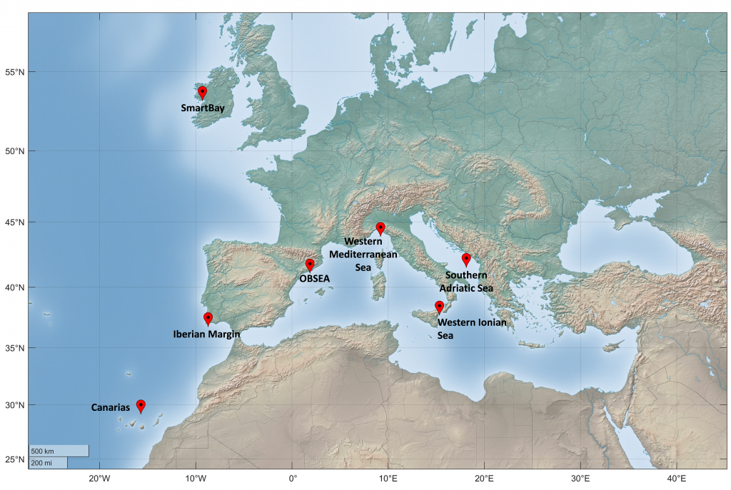
The map below shows the seven Facilities providing access in this 2026 Call.
Each Facility has its particular features as they are operated by different institutions and their goals are diverse. Therefore it is advisable for the potential user to read the Facility information prior to sending the Letter of Intent. If specific technical information is needed to better identify the Facility that best suits the applicant needs, the contacts provided for each Facility will gladly advise the potential user.
The acknowledgment and signature of the Regional Facility manager is necessary to be able to submit the project proposal to a specific cut-off date.
1. SmartBay
Access Provider: Marine Institute, Ireland
Location: 53°14’ N, 9°16’ W, 25m water depth
SmartBay is Ireland’s national marine test site and observatory that provides continuous oceanographic and environmental data in near-real time.
Intermediate Call Participation: February 28th, April 30th, June 30th, August 31st, October 31st and December 31st
Operational constraints: None
Costs and Funding: EMSO provides 100% funding of Access Units and up to 15000€ of funding, of which up to 4000€ for travel.
| Available Daily Access to Facility | Access Units |
| MoA1a: Remote Access with Sensor Hosting | 0,50 AU |
| MoA1b: Remote training | 0,50 AU |
| MoA3a: In Person Access at Lab or Cruise with Sensor Hosting | 1 AU |
| MoA3b: In Person Access at Lab or Cruise for training | N/A |
Website address: www.smartbay.ie
Contact: Conall O’Malley (conall.omalley[AT]marine[DOT]ie)
Description of the infrastructure:
SmartBay is Ireland’s national subsea cabled observatory that provides continuous oceanographic and environmental data in near-real time. The observatory can be accessed by users to test innovative and novel marine technologies and sensors.
The SmartBay observatory is a cabled observatory which has been operational since 2015 in Galway Bay. The observatory includes a fiber optic data and power cable which provides connectivity to a sub-sea sensor hosting platform. The sub-sea platform includes 17 electrical input/output “science” ports, 4 hybrid input/output “optical” ports and one coaxial port. The science ports can deliver 75W at different combinations of 12, 15, 24V DC with either serial or ethernet communication protocols (up to 100 Mbps) to scientific instruments. Instruments can be deployed and recovered on the science ports year round. The observatory includes a number of permanent instruments which are used to monitor background environmental parameters and against which new and novel sensors can be tested. The permanent or ‘core’ suite of sensors deployed on the SmartBay observatory includes:
- Conductivity, Temperature and Depth
- Dissolved Oxygen
- Combined Turbidity and Fluorescence sensor
- Acoustic Doppler Current Profiler
- High frequency hydrophone
- High definition video camera
- Wide angle video camera
- Scanning sonar
Measured variables
- Atmosphere:
- Atmospheric pressure, air temperature, wind speed and direction (3m asl)
- Ocean-Air interface:
- Spectral wave data, surface current (0m)
- Dissolved oxygen (1m)
- Water column:
- Temperature, electrical conductivity, salinity, fluorescence (Chl-a), turbidity, sound, video (25m)
- Currents profile (0-25m)
- Seafloor:
- None
Support offered
Logistical and operational support
ICT team for data acquisition and transmission
Near-real time data visualization on online data portal
Remote management of instruments via VPN connections
2. Iberian Margin
Access Provider: IPMA and CCMAR, Portugal
Location: 36°50’ N, 8°55’ W, 150m water depth
CCMAR moorings are installed 10 nm south of Sagres, Portugal, with anchors at 200 m depth.
Intermediate Call Participation: June 30th, August 31st and October 31st
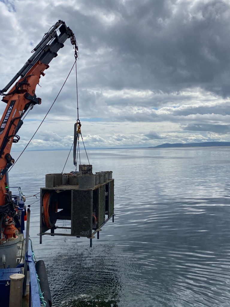
Operational constraints: Full mooring deployment and recovery dependent on ship availability.
Costs and Funding: EMSO provides 100% funding of Access Units and up to 15000€ of funding, of which up to 4000€ for travel.
| Available Daily Access to Facility | Access Units |
| MoA1a: Remote Access with Sensor Hosting | 0,50AU |
| MoA1b: Remote training | 0,50AU |
| MoA3a: In Person Access at Lab or Cruise with Sensor Hosting | 1,00AU |
| MoA3b: In Person Access at Lab or Cruise for training | 1,00AU |
Website address: emso-pt.pt/
Contact: Carlos Sousa (cssousa[AT]ualg[DOT]pt)
Description of the infrastructure:
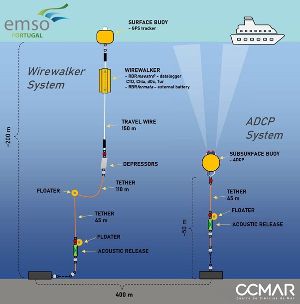
The CCMAR infrastructure is subdivided in two independent mooring systems, configured in order to acquire a continuous and very detailed dataset of the first 150 m of the ocean water column:
- Vertical profiler (Wirewalker): wave powered profiler that is in continuous movement (~5 profiles per hour from 150 m to 0 m depth), equipped with different sensors that allow a 6-month uninterrupted operation at 2 Hz sampling frequencies. Measured parameters are conductivity, temperature, pressure (depth), dissolved oxygen, chlorophyll a, and turbidity.
- Subsurface buoy: installed at 150 m depth, equipped with an upward facing Acoustic Doppler Current Profiler (ADCP).
The CCMAR infrastructure is based on current off-the-shelf state-of-the-art technologies in order to target low cost observational systems (in terms of acquisition, deployment, operation, and maintenance). First pilot deployments were made in 2021 and 2022, from late May to early October. Main scientific goals are: Long-term variability of the upper ocean structure (thermocline, mixed layer, stratification); mesoscale activity related to Upwelling and Coastal Counter Currents; Mediterranean outflow/inflow signal; Improving the regional numerical model parametrization.
Operational safety (e.g. collision hazards, fishing) is assured by an insured exclusion area (TUPEM), of roughly 500 m by 500 m, that is identified in nautical charts
Hosting components
- Mooring line (from 150 m depth to 180 m depth)
- 30’’ Subsurface buoy frame (at 150 m depth)
- Vertical profiler (Wirewalker)
- Small Surface buoy
Measured variables
- Atmosphere:
- None
- Ocean-Air interface:
- None
- Water column:
- Temperature, conductivity, pressure, dissolved oxygen, chl-a, turbidity, current velocity (vertical profiler from 0 to 150m depth)
- Temperature, pressure (150m)
- Currents profile (0-150m)
- Seafloor:
- None
Other capabilities and services
- Operational testing area in open ocean
Support offered
Logistical and scientific support.
3. EMSO Canarias
Access Provider: PLOCAN, Spain
Location: 36°10’ N, 15°30’ W, 3610m water depth
The EMSO Canarias/ESTOC station (European Station for Time-Series in the Ocean Canary Islands) is a deep-ocean facility located in the North-East Atlantic, 60 nautical miles (112 km) north of Gran Canaria, operational since 1994. The mooring system includes a surface oceanic buoy and a multiparametric sampling line extending down to 3,610m water depth, providing continuous long-term monitoring of key meteorological and oceanographic variables in the central North-East Atlantic. The site is located far from coastal and island influences, serving as an open-ocean reference for oceanographic processes and the validation of satellite observations.
Intermediate Call Participation: February 28th and October 31st
Operational constraints: Available only during maintenance cruise, dependent on instrument availability.
Costs and Funding: EMSO provides 100% funding of Access Units and up to 15000€ of funding, of which up to 4000€ for travel.
| Available Daily Access to Facility | Access Units |
| MoA1a: Remote Access with Sensor Hosting | 1,00AU |
| MoA1b: Remote training | 1,00AU |
| MoA3a: In Person Access at Lab or Cruise with Sensor Hosting | 1,00AU |
| MoA3b: In Person Access at Lab or Cruise for training | 1,00AU |
Website address: https://plocan.eu/en/installations/ocean-observatory
Contact: Dr. Andrés Cianca (andres.cianca[AT]plocan[DOT]eu)
Description of the infrastructure:
The infrastructure comprises:
- Instrumented surface buoy for meteorological and ocean surface data
- Multidisciplinary mooring with sensors distributed throughout the water column for temperature, salinity, dissolved oxygen, pressure, currents (ADCP), nutrients, pCO₂, pH, and additional physical and biogeochemical variables
The facility supports multidisciplinary research in several priority areas:
- Time series monitoring of the Eastern North Atlantic Ocean
- Studying water masses mixing processes and water mass properties
- Investigating biogeochemical cycles and long-term trends
- Monitoring ocean sound in accordance with the MSFD (Descriptor 11 — D11C2, continuous noise): long-term ambient-noise time series in 1/3-octave bands centred at 63 and 125 Hz.
- Assessing cetacean presence and seasonal occurrence via passive acoustic monitoring (PAM): detection of whistles and echolocation clicks with effort-standardised metrics to inform MSFD biodiversity assessments (Descriptor 1 — cetaceans).
Hosting components
- Buoy
- Mooring line
Measured variables
-
- Atmosphere:
- Temperature, barometric pressure and wind speed and direction @ 3m of altitude
- Ocean-Air interface:
- None
- Water column:
- Temperature (0, 80, 150, 800, 1200m)
- Salinity (0, 80, 150, 800, 1200m)
- Dissolved oxygen (0, 80, 150, 800 1200m)
- Fluorometer (0, 80m)
- Nitrates (150m)
- pH and pCO2 (0m)
- Currents (0-80m) and 150m
- Underwater sound (180m)
- Seafloor:
- None
Other capabilities and services:
None
Support offered
Support offered is mainly logistical, technological and scientific.
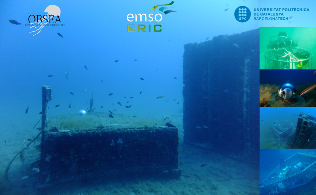
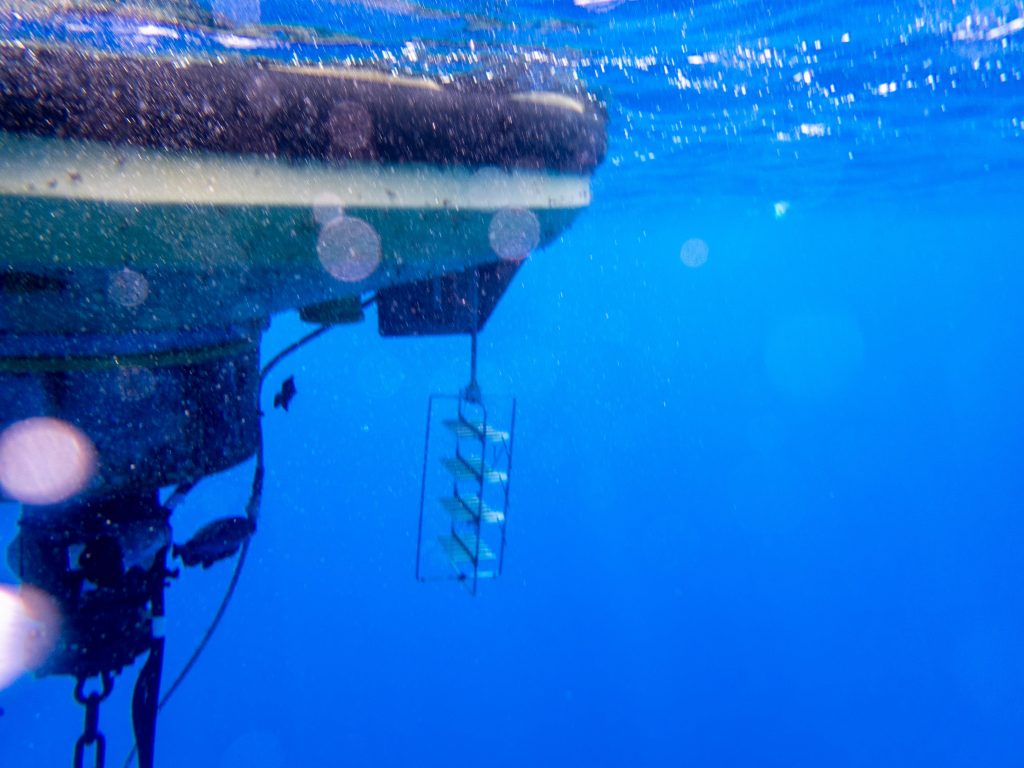
4. OBSEA (Expandable Seafloor Observatory)
Access Provider: Universitat Politècnica de Catalunya, Spain
Location: 41°10′ N, 1°45′ E; 20m water depth
Located 4km off Vilanova i la Geltrú port
Intermediate Call Participation: February 28th, April 30th, June 30th, August 31st, October 31st and December 31st
Operational constraints: None
Costs and Funding: EMSO provides 100% funding of Access Units and up to 15000€ of funding, of which up to 4000€ for travel.
| Available Daily Access to Facility | Access Units |
| MoA1a: Remote Access with Sensor Hosting | 1,00AU |
| MoA1b: Remote training | 1,00AU |
| MoA3a: In Person Access at Lab or Cruise with Sensor Hosting | 1,00AU |
| MoA3b: In Person Access at Lab or Cruise for training | 1,00AU |
Website address: www.obsea.es
Contact: Joaquin del Rio (joaquin.del.rio[AT]upc[DOT]edu)
Description of the infrastructure:
OBSEA is a cabled seafloor observatory located 4 km off the Vilanova i la Geltru coast in a fishing protected area. It is connected to the coast by an energy and communications mixed cable (OceanOPS WMO number: 6103565).
- Provides an uninterrupted power supply to the scientific instruments.
- Offers a high bandwidth communication link.
- Real time data is available and problems encountered in battery powered systems are avoided.
- An optical Ethernet network that transmits data continuously to marine sensors connected to the observatory.
Hosting components:
- Mooring Line
- Surface buoy
- Cabled Seafloor station
Measured variables
- Atmosphere:
- Land station: Air temperature, humidity, pressure, wind speed and direction and rain.
- Sea station buoy: Air temperature and pressure, wind speed and direction. Additional measures are platform GPS position, orientation and attitude
- Water column: Acoustic wave and current Doppler profiler (0-20m)
- Seafloor: Temperature, salinity, depth, sound, seafloor acceleration, video (20m)
Variables also available at https://data.obsea.es/erddap/info/
Other capabilities and services
- Pressure chamber
Support offered
Training, logistical, technological and scientific support for all components
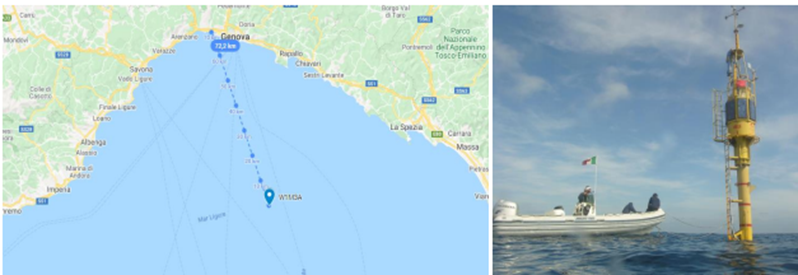
5. Western Mediterranean Sea (W1M3A)
Access Provider: National Research Council (CNR), Italy
Location: 43°50’ N, 9°07’ E, 1200m water depth
About 40 nm off the coast, southward from Genoa, Italy.
Intermediate Call Participation: February 28th, April 30th, June 30th, August 31st, October 31st and December 31st
Operational constraints: None
Costs and Funding: EMSO provides 100% funding of Access Units and up to 15000€ of funding, of which up to 4000€ for travel.
| Available Daily Access to Facility | Access Units |
| MoA1a: Remote Access with Sensor Hosting | 0,77AU |
| MoA1b: Remote training | 0,67AU |
| MoA3a: In Person Access at Lab or Cruise with Sensor Hosting | 1,00AU |
| MoA3b: In Person Access at Lab or Cruise for training | 1,00AU |
Website address: www.w1m3a.cnr.it
Contact: Roberto Bozzano (roberto.bozzano[AT]cnr[DOT]it), Sara Pensieri (sara.pensieri[AT]cnr[DOT]it)
Description of the infrastructure:
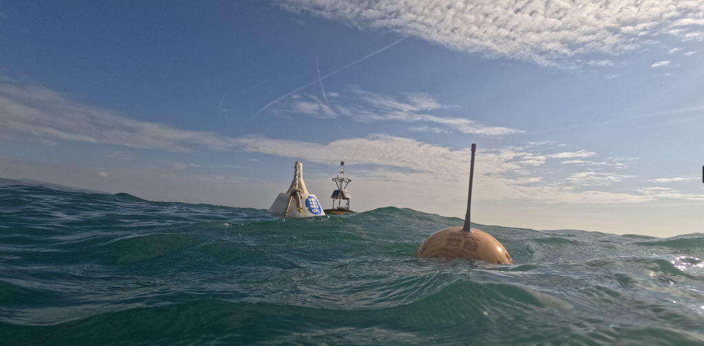
The infrastructure is a single multidisciplinary observatory mooring located in the Western Mediterranean Sea with real-time and delayed mode capability. The W1M3A observing system is composed of a large spare buoy and a sub-surface mooring. The spar buoy was specifically designed for air-sea interaction studies and the collection of meteorological data even in rough seas. Stability is the basic feature of this type of buoy with respect to the other more classical approaches based on discus-shaped buoys. The buoy is a stable measuring platform since its total mass, the unity buoyancy at the sea level, and presence of a damping disk allow for negligible sensitivity of the waves. The overall structure is 51-meter-long with a dry-weight of about 12 tons. The observatory is permanently moored on the seabed through a 2000 m long slack polypropylene mooring cable terminated by ship chains and an anchor. The buoy spans a watch circle of 3 km of diameter to sustain ocean currents, winds, and waves. The pole emerges about 15 meters above sea level, whereas the remaining 36 meters remain submerged. On the upper mast, the meteorological instruments are installed. At about 7 meter above the mean sea level, a small closed space hosts the electronic systems for data collection. Along the underwater pole, at several depths, instruments are deployed. All electronic systems and most sensors are powered by a wind/solar system that recharges two separate batteries. Acquired data are stored on-board but a subset of the data is transmitted ashore through a satellite link. The sub-surface mooring is a standard oceanographic mooring composed of pieces of Kevlar rope with floats kept in position by a ballast on the sea bottom which can be detached using a pair of acoustic releasers. Along the mooring line, several CTDs are deployed at different depths. The observatory is located in the more inland basin of the Mediterranean Sea: in this area, the particular orographic constraints and the thermal contrast between land and sea give rise to specific local effects that influence the general circulation of both atmosphere and ocean. The area is also part of the Pelagos Sanctuary for Mediterranean Marine Mammals that is a special marine protected area extending about 90.000 km2 between Italy, France and the Island of Sardinia. With respect to the overall Mediterranean basin, this area is characterized by very high levels of primary productivity, caused by the interplay of oceanographic, climatic and geomorphological factors. Two main currents, one flowing north along Corsica and the other along the coast of Tuscany, join at the center of the basin giving rise to a quasi-permanent cyclonic current that partially turns towards west flowing along the coast of Liguria and mainland France. This flow acts as a boundary between coastal and offshore waters and noteworthy biological activity is generated along this front. North-westerly winds provoke vertical mixing and coastal upwellings, also lifting up from the deep waters nutrients and organic substances into the euphotic zone. High levels of primary production support a conspicuous biomass of highly diversified zooplankton fauna, that, in turn, attract to the area various levels of predators, mammals included.
Hosting components
- Surface buoy (atmospheric, air-sea interface, water column down to 40m depth)
- Mooring line (physics and bio-geochemistry down to 1000m depth)
Measured variables
- Atmosphere:
- Atmospheric pressure (8m asl)
- Horizontal wind speed, gust wind speed, wind direction relative to true North, air temperature in dry bulb, relative humidity, total incoming radiation, hourly precipitation rate, longwave incoming radiation (10m asl).
- Ocean-Air interface: Sea surface temperature (0m)
- Water column:
- Temperature, electrical conductivity, practical salinity (different depths)
- Turbidity, pCO2, dissolved oxygen, chlorophyll-a fluorescence (6m)
- Underwater sound
- Seafloor:
- None
Other capabilities and services
- New installed equipment control and data available in near-real-time ashore.
- Near-real-time data visualization and download available from CNR website
- Deployment of high-cost, relatively large and power consuming devices is possible on the surface buoy
Support offered
Logistical, technological and scientific support for all components.
Electronic lab and workshop labs available to adapt parts.
Calibrated equipment for reference measurements and water sample analysis.
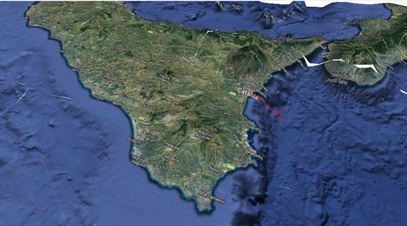
6. Western Ionian Sea
Access Provider: INGV, INFN, CNR-ISMAR, Italy
Location: 37.55 N, 15.40 E (WGS84) 2100 m water depth (fiber optic cable) / 37°32.5N 15°23.9 E (WGS84) 2025 m water depth (mooring line)
Electro-optical subsea cable from shore lab -port of Catania, East Sicily- to deep sea and Mooring Line
Intermediate Call Participation: April 30th, June 30th, August 31st, October 31st and December 31st
Operational constraints: The physical access to the Fiber Optic cable is available at the shore station for connection to one of the optical fibres of the submarine cable. User equipment must comply with EU regulation. Access to shore station must be authorized by the director of INFN-LNS.
Physical access to the mooring system shall be permitted only under favourable weather and sea conditions, within approved maintenance windows (typically in spring and autumn), and solely by authorized personnel using approved vessels and equipment, subject to the permits required by the Italian port authorities and with the approval of CNR as the vessel’s owner. Access activities shall not generate loads exceeding design limits nor interfere with normal operations or environmental protection requirements.
Costs and Funding: EMSO provides 100% funding of Access Units and up to 15000€ of funding, of which up to 4000€ for travel. Access Units per project limited to 30.
| Available Daily Access to Facility | Access Units |
| MoA1a: Remote Access with Sensor Hosting | 1,00AU |
| MoA1b: Remote training | 1,00AU |
| MoA3a: In Person Access at Lab or Cruise with Sensor Hosting | 1,00AU |
| MoA3b: In Person Access at Lab or Cruise for training | 1,00AU |
Website address: www.moist.it/sites/western_ionian_sea/2 and https://westernioniansea.ingv.it/
Contact: Davide Embriaco (davide.embriaco[AT]ingv[DOT]it), Nadia Lo Bue (nadia.lobue[AT]ingv[DOT]it)
Description of the infrastructure:
The Western Ionian Sea site is located in the central Mediterranean basin, Eastern Sicily Island (Southern Italy). It is based on infrastructures developed over the last decades and undergoes continuous enhancements. The area is prone to numerous natural hazard issues due to high seismicity and the presence of Etna Volcano, which is one of the largest active sub-areal volcano in European continent and it is positioned on the subduction plate. The area is strategically relevant also for the oceanographic circulation between the Eastern and Western Mediterranean Sea through the Messina Strait and the Sicily Channel. Moreover, the position is a key site for analyzing the mechanism governing the Ionian dynamics and so on its role in the general eastern Mediterranean circulation pattern.
Beyond its geophysical relevance, the site occupies a strategic position connecting the eastern and western Mediterranean, where exchanges through the Strait of Messina and the Sicily Channel regulate water-mass redistribution. This makes the area particularly suitable for investigating Ionian Sea dynamics, deep-water circulation linking the Levantine and southern Adriatic basins, and their role in the broader eastern Mediterranean circulation. Volcanic ash inputs from Mount Etna further enhance the site’s scientific value by potentially supplying nutrients that stimulate primary production and contribute to biological CO₂ drawdown.
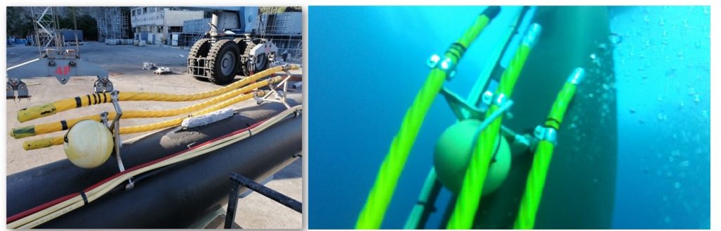
Since 2021, the Western Ionian Sea infrastructure has been enriched by the multiparameter mooring Galatea, with the objective of extending observations throughout the water column and improving the understanding of ocean dynamics and variability. Galatea is equipped with a suite of multiparametric sensors measuring pressure, temperature, salinity, dissolved oxygen, and turbidity, as well as Acoustic Doppler Current Profilers (ADCPs). In addition, a sediment trap is deployed to collect particulate matter and investigate the contribution of volcanic ash to the marine ecosystem. The instruments are installed at multiple depth levels, from the seafloor up to about 400 m, in order to minimize interference with fishing activities.
Galatea is currently operated by INGV and ISMAR, contributing to long-term observations of physical, biogeochemical, and sedimentary processes in this key region of the Mediterranean.
The cabled infrastructure is composed of:
1) an onshore station, hosted in the INFN – LNS ancillary laboratory in the Catania Harbour, where the real-time acquisition and power feeding system of the marine infrastructure components are located;
2) a “Y” shaped main electro optical-cable from the onshore station to two cable termination frames at 2100m depth, about 28 km off the coast;
3) two cable termination frames equipped with electro optical ROV mateable connectors. The south termination is managed by INFN. The north branch is managed by INGV;
4) at the north termination a Junction Box which provide power and data transfer connectivity to two seafloor multidisciplinary observatories and a 21Km long smart cable.
The Galatea mooring line technical design is the following:
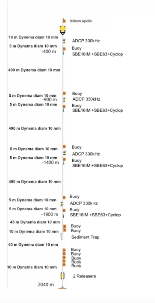
Hosting components
- Land Station
- Electro optical cable (access only to fiber-based measurement is available at present)
- Seafloor observatories
- Galatea Mooring System
Measured variables
-
- Atmosphere:
- None
- Atmosphere:
- Ocean-Air interface:
- None
- Water column: temperature, salinity, particle matter (turbidity sensor), particle matter (sediment trap), dissolved oxygen
- Seafloor: temperature, conductivity, pressure, sea current velocity, turbidity, dissolved oxygen, acoustics, seismics.
Other capabilities and services
- Working room with IT equipment and high speed internet connection at land station (FO access)
- Ability to perform CTD cast on the mooring point
Support offered
Logistical, technological and scientific support.
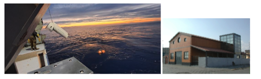
7. Southern Adriatic Sea (E2M3A)
Access Provider: National Institute of Oceanography and Applied Geophysics (OGS), Istituto di Scienze Polari (ISP CNR), Italy
Location: 41°31′ N, 18°04′ E, 1185m water depth
The station is located in the South Adriatic Sea
Intermediate Call Participation: February 28th, April 30th, June 30th and August 31st
Operational constraints: None
Costs and Funding: EMSO provides 100% funding of Access Units and up to 15000€ of funding, of which up to 4000€ for travel.
| Available Daily Access to Facility | Access Units |
| MoA1a: Remote Access with Sensor Hosting | 0,64AU |
| MoA1b: Remote training | 0,75AU |
| MoA3a: In Person Access at Lab or Cruise with Sensor Hosting | 1,00AU |
| MoA3b: In Person Access at Lab or Cruise for training | 1,00AU |
Website address: http://nettuno.ogs.trieste.it/e2-m3a/
Contact: Vanessa Cardin (vcardin[AT]ogs[DOT]it)
Description of the infrastructure:
The EMSO Regional Facility for the South Adriatic Sea includes two sites, namely the South Adriatic Pit observatory (E2M3A) and the Shelf-slope observatory site (BB and FF) located in the Western part of the basin. The E2M3A site is a two mooring system where the main one hosts the surface buoy instrumented with meteorological station and radiometers to collect air-sea interaction measurements, sensors for physical (temperature and salinity) and biochemical (oxygen, partial CO2 and pH) parameters distributed in the mixed layer, telemetry and services. The surface buoy collects the acquired data and transmits them in real time to the on-line server. The secondary mooring line houses an instrumental chain with sensors at different depths for physical and chemical measurements from the seafloor to the intermediate layer. Each of the BB and FF moorings consists of a single mooring of about 100 m that measures physical and geochemical parameters and have the role of intercepting the passage of North Adriatic Dense Water (NAdDW), which forms during the winter between Trieste and Ancona, as it sinks.
Hosting components:
-
- Surface Buoy
- 3 mooring lines
- Additional stand-alone moorings
Measured variables
- Atmosphere: Wind speed and direction, relative humidity, air temperature, sea temperature, atmospheric pressure, solar radiation
- Ocean-Air interface: Temperature, salinity, oxygen, pCO2, pH, fluorescence (2m, 15m)
- Water column: Temperature, salinity, dissolved oxygen, fluorescence, currents, sediment trap
- Seafloor: Sediment trap
Other capabilities and services
- Data curation (acquisition, validation, storage)
- Training
- Inter-comparison tests
Support offered
Logistical, technological and scientific support for all components.
ONGOING
Project Name: LoRa – Long-term Underwater Radioactivity Sensor Validation
Project Reference: EE-PA_202602_01
User: PLOATECH – Ploa Technology Consultants S.L. (Spain)
Host Facility: OBSEA (Spain)
Keywords: sensor, gamma radiation, long-term validation, geohazards, TENORM
Access Units granted: 173.0 (138400 €)
Funding granted: 13100 €
Project Name: MARIMET – Marine Metal Availability and DOM Reactivity
Project Reference: EE-PA_202512_03
User: University of Lleida (Spain)
Host Facility: OBSEA (Spain)
Keywords: trace metals, micronutrients, dissolved organic matter DOM, metal dynamics, diffusive gradients in thin films DGT
Access Units granted: 28.0 (22400 €)
Funding granted: 11700 €
Project Name: UVP6-BF – A new dedicated UV-C system for the protection of the UVP6 porthole against biofouling
Project Reference: EE-PA_202504_01
User: Sorbonne Université – LOV (France)
Host Facility: OBSEA (Spain)
Keywords: camera, plankton, particles, UV-C lights, low consumption, biofouling protection
Access Units granted: 360.0 (288000 €)
Funding granted: 9700 €
Project Name: Seagrass Blue – SGB
Project Reference: EE-PA_202402_01
User: Seagrass Blue, Eauligo SARL (France)
Host Facility: OBSEA (Spain)
Keywords: carbon removal, seagrass, biodiversity, floating farm pods, marine bee AUVs
Access Units granted: 75.0 (60000 €)
Funding granted: 15000 €
Project Name: LOCOLAND – Low cost landers for complementary sustained near-bed monitoring at EMSO deep sites
Project Reference: EE-PA_202312_01
User: Spanish institute of Oceanography CSIC-IEO (Spain)
Host Facility: Iberian Margin (Portugal)
Keywords: low cost, landers, LanderPick, SSBL system, precise positioning
Access Units granted: 186.5 (93250 €)
Funding granted: 10700€
COMPLETED
Project Name: WECDA – Wave Energy Converter for Drifter Applications
Project Reference: EE-PA_202502_01
User: Brno University of Technology (Czechia)
Host Facility: OBSEA (Spain)
Keywords: lagrangian drifter, wave energy, energy harvesting, rolling mass resonator, low-frequency motion
Access Units granted: 71.0 (56800 €)
Funding granted: 12350 €
Project Name: SEALS – Submarine noise-Evaluation & Analytics using Low-cost Sustainable-sensing
Project Reference: EE-PA_202306_01
User: National Oceanography Centre (United Kingdom)
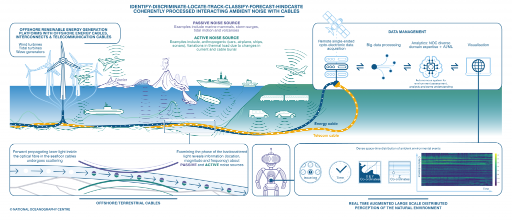
Host Facility: Western Ionian Sea (Italy)
Keywords: distributed fiber optical sensors, DFOS, big data streams, algorithms, noise
Access Units granted: 49.0 (15925 €)
Funding granted: 10745 €
Project Name: Levels and air-sea exchange of persistent organic pollutants in the marginal sea of Europe: contribution to the global monitoring effort AQUA-GAPS/MONET
Project Reference: EE-PA_202310_01
User: Masaryk University (Czechia)
Host Facility: Cretan Sea (Greece)
Keywords: persistent organic pollutants, contaminants, air-sea exchange fluxes, seasonal variations
Access Units granted: 182.0 (131040 €)
Funding granted: 1200 €
Project Name: SEASNAKE – Sea trials for biofouling of a dynamic umbilical
Project Reference: EE-PA_202210_01
User: Research Institutes of Sweden (Sweden)
Host Facility: Western Mediterranean Sea (Italy)
Keywords: materials, corrosion, biofouling, umbilical cable, long-term exposition, antifouling painting
Access Units granted: 222.0 (156193 €)
Funding granted: 11000 €
Project Name: FOOD – Future Ocean Observation Drifter
Project Reference: EE-PA_202404_01
User: CLS – Collecte Localisation Satellites (France)
Host Facility: OBSEA (Spain)
Keywords: wooden drifter, prototype, plastic reduction, testing, telemetry, sensors
Access Units granted: 60.0 (48000 €)
Funding granted: 5000 €
Report: Download here
Project Name: CUPIDO – CalcUlating the strength of the Plastic pump In counteracting the Deep export of Oceanic carbon
Project Reference: EE-PA_202208_01
User: British Antarctic Survey (United Kingdom)
Host Facility: Southern Adriatic Sea (Italy)
Keywords: microplastics, seasonal variation, zooplankton, deep ocean layer, plastic pump, carbon pump
Access Units granted: 241.4 (159310 €)
Funding granted: 9000 €
Project Name: Calibration-free pH Sensors
Project Reference: EE-PA_202204_01
User: ANB Sensors Ltd. (United Kingdom)
Host Facility: OBSEA (Spain)
Keywords: pH sensor, validation, biofouling, user experience, long-term deployment
Access Units granted: 189.0 (151200 €)
Funding granted: 10800 €
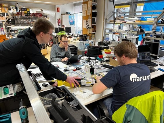
Project Name: TRIPLE-VTESTS
Project Reference: EE-PA_202204_02
User: University of Bremen/Marum (Germany)
Host Facility: OBSEA (Spain)
Keywords: autonomous underwater vehicle, USBL, Doppler velocity log, artificial intelligence
Access Period: 06/02/2023 to 19/02/2023
Access Units granted: 14.0 (11200 €)
Funding granted: 11000 €
Report: Download here
Data: Download here