Project Description
IBERIAN MARGIN
SUMMARY
The area of Gulf of Cadiz is very important for geo-hazards. It was the site where one of the worst earthquakes that hit Europe occurred in 1755, coupled with a destructive tsunami. Here African and European tectonic plates converge. It is a seismic volcanic region. The Iberian Margin is also a pivotal ocean region where Atlantic and Mediterranean exchange waters, with the later spreading at intermediate levels playing a key role in the salt and heat budget and AMOC (Atlantic Meridional Overturning Circulation). The Iberian Margin is the northernmost region of the productive CCUS (Canary Current Upwelling System), one of the four EBUS (Eastern Boundary Upwelling Systems) of the global ocean, where a highly variable upwelling regime dominates along with a strong mesoscale activity. The geologic and oceanographic features of this region favour the presence of highly diverse benthic communities and have also a central role in the distribution of several marine mammals and fish species.

General information
Location: SW Iberian Margin
Distance from land: 20 km
Max water depth: 1200 m
Date 1st deployment: May 2021
Supported by: Portugal
Operated by: EMSO Portugal
Website: emso-pt.pt
Status: running
Regional Team Leader: Carlos Sousa, IPMA
Description of the infrastructure
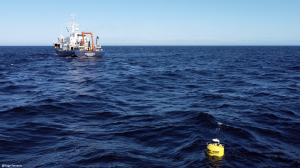
The Iberian Margin is currently composed of two sub-systems, deployed in the proximity of Cape St. Vincent (IbMa-CSV), tailored to measure EOV’s (CTD, dissolved oxygen, turbidity, total chlorophyll-a, CDOM, PAR, currents) at different depth ranges:
- A wave powered water column vertical profiler (Wirewalker), delivering ~5 profiles/hour from the near surface to 150m depth, scalable to reach 500m depth, depending on travel wire;
- A subsurface moored platform (EGIM), currently planned to be deployed ~1100 m depth (pilot dataset from ~200m depth).
OBJECTIVES: To know the physical and biogeochemical characteristics of the Iberian Margin waters and their variability in a wide range of timescales to understand and predict the ecosystem functioning in global change scenarios. To establish references for model validation, to feed models with near real time data, and improve model parametrizations towards better forecasting. To construct long-term oceanographic time series as a scientific patrimony and a legacy for future marine research and management.

